Here's something you might be interested in.
Ask a Hipster — Advice you didn't know you needed
Big Screen — Movie commentary
Blurt — Music's inside track
Booze News — San Diego spirits
Classical Music — Immortal beauty
Classifieds — Free and easy
Cover Stories — Front-page features
Drinks All Around — Bartenders' drink recipes
Excerpts — Literary and spiritual excerpts
Feast! — Food & drink reviews
Feature Stories — Local news & stories
Fishing Report — What’s getting hooked from ship and shore
From the Archives — Spotlight on the past
Golden Dreams — Talk of the town
The Gonzo Report — Making the musical scene, or at least reporting from it
Letters — Our inbox
Movies@Home — Local movie buffs share favorites
Movie Reviews — Our critics' picks and pans
Musician Interviews — Up close with local artists
Neighborhood News from Stringers — Hyperlocal news
News Ticker — News & politics
Obermeyer — San Diego politics illustrated
Outdoors — Weekly changes in flora and fauna
Overheard in San Diego — Eavesdropping illustrated
Poetry — The old and the new
Reader Travel — Travel section built by travelers
Reading — The hunt for intellectuals
Roam-O-Rama — SoCal's best hiking/biking trails
San Diego Beer — Inside San Diego suds
SD on the QT — Almost factual news
Sheep and Goats — Places of worship
Special Issues — The best of
Street Style — San Diego streets have style
Surf Diego — Real stories from those braving the waves
Theater — On stage in San Diego this week
Tin Fork — Silver spoon alternative
Under the Radar — Matt Potter's undercover work
Unforgettable — Long-ago San Diego
Unreal Estate — San Diego's priciest pads
Your Week — Daily event picks
The Enemy on McGinty Mountain
"Who am I to dictate who should or should not go hiking?”
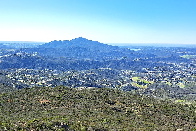
View from McGinty looking west at San Miguel.
- McGinty Mountain
- Located near Jamul, McGinty Mountain is a moderately strenuous hike. With a length of 4.5 miles and an elevation gain of around 1,300 feet, the hike will take most people 2 to 3 hours to complete. Dogs are allowed.
- Distance from downtown San Diego: 19 miles
- Hike length: 4.5 miles • Difficulty: Moderately strenuous • Season: November - May
“You’re the enemy now, dude,” hissed Nate.
Nate is a close friend of mine who I’ve known for about six years, and like me, he enjoys a difficult hike. The two of us were snaking our way up McGinty Mountain, which overlooked Jamul and Rancho San Diego. Nate grew up in the area, and it was one of his favorite hikes.
“I’m the enemy?” I asked teasingly while looking out at Jamul. The sky was crystal-clear with nary a cloud in sight, and the valley was lush with green from the recent rainstorms.
“You are,” Nate growled. “First you wrote about Lawson Peak, and now you’re going to write about McGinty. You’re revealing all my favorite hiking spots!” His face was completely flushed, but I couldn’t tell whether it was red with rage or ruddy from exhaustion. Nate cleared his throat: “If you keep writing about these remote hikes, we’re going to start bumping into tech bros who wear Patagonia fleece vests and blast music on the trail. Is that what you want? To turn every hiking trail into the frontside of Cowles?”
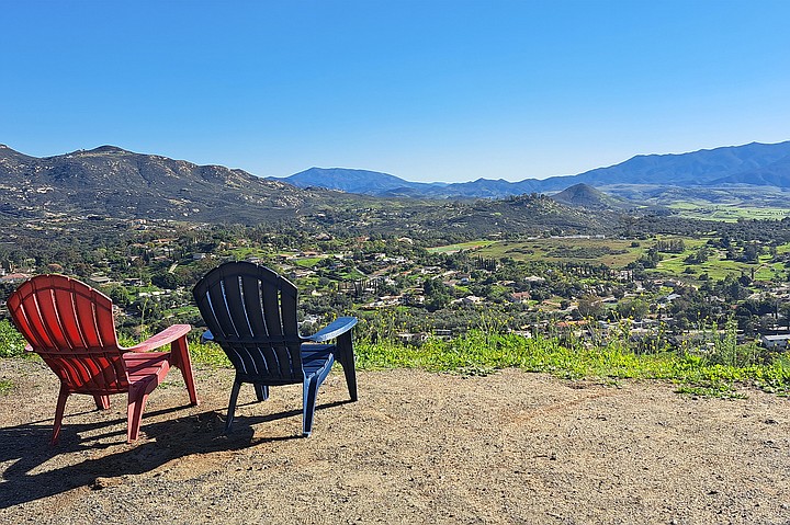
Plateau with chairs overlooking Jamul.
I smiled slyly and quipped back, “So then I shouldn’t write about your alternative route up McGinty?”
“Absolutely off limits!” Nate boomed, his voice stern. “You’d be a real S.O.B if you told people about my secret path.”
“Mmmk,” I muttered while typing his response into my phone to reference later for this article. “But just so you know, you sound like a Karen — using your own privilege to demand things be done your way.” I expected Nate to quip back, but to my surprise, he remained silent. I lifted my head to look at his face and saw it was flush with rage. I wanted my words to sting, not to insult. I sighed, irritated by my mouth’s inability to play nice.
Over the next few minutes, I endured an awkward silence. I could tell Nate was chewing over some harsh words for me, but he kept quiet. Fortunately — and no one tells you this — one of the upsides to hiking a lot is that you get used to chafing, especially when two people butt heads. Eventually, we both smoothed over our ruffled feathers and resumed chatting, though we stuck to more pleasant topics.
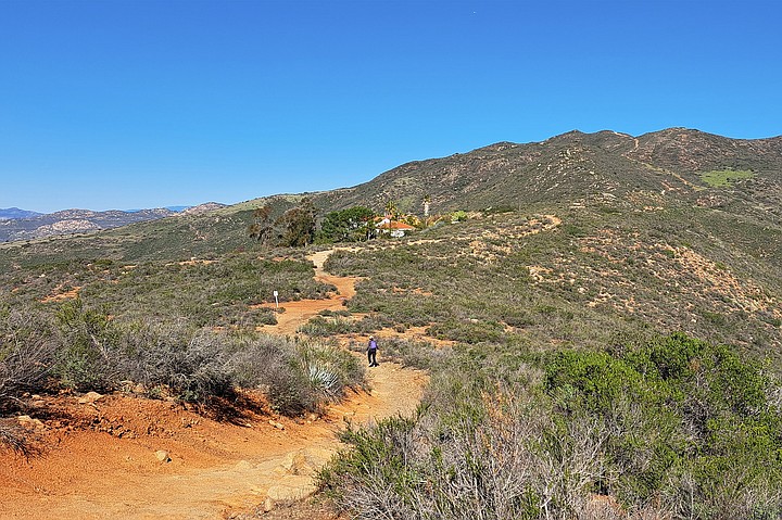
Flat broad ridge that winds behind mansions.
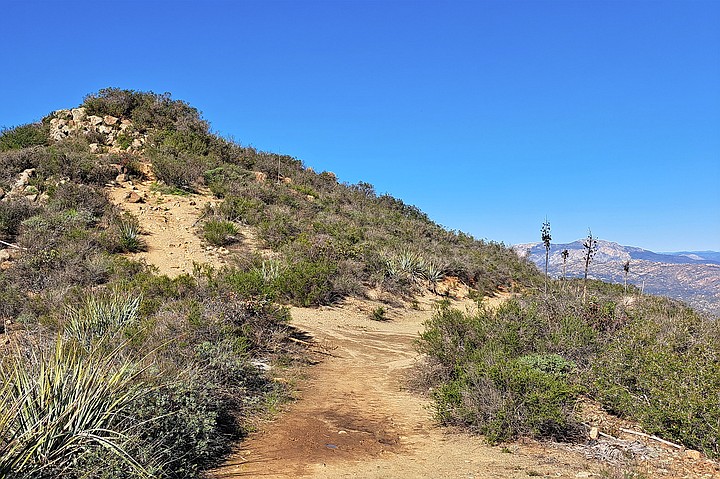
As we bantered, Nate and I climbed up the first of McGinty’s two steep sections. Here, the path slopes up from the parking lot into a series of gentle switchbacks; hikers gain about 550 feet over three-quarters of a mile. As a reward, they are met by a small plateau that overlooks Jamul. To our surprise, someone had carried up two colorful Adirondack chairs and planted them near the edge of the hill so that we could sit and take in the view. This time of year, the valley below looked like a small village: grassy meadows mixed with half-hidden homes. Surrounding the valley was a ring of hills that receded into the distance until they lapped against the base of San Miguel Mountain to the east and Otay Mountain to the south. But Nate and I never stop to rest until we reach the peak, so I snapped a photo and we carried on.
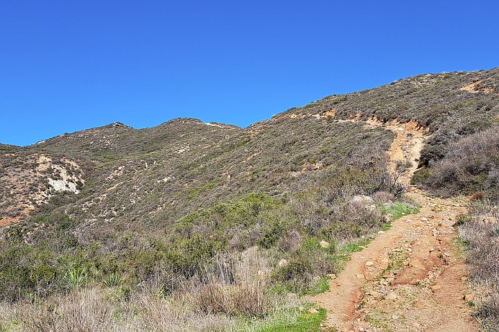
Halfway up the second steep section.
The path briefly climbed before leveling off along a broad ridge that meandered behind several picturesque mansions. As we passed the homes, we began the second steep section of the hike. Here, the ground rises sharply and gains 600 feet of elevation over three-quarters of a mile. As our breathing became more labored and the conversation withered, I lowered the brim of my hat so that I could see only six feet ahead of me. I’ve found that by looking down and focusing on my breathing, it’s easier to endure the climb. Still, I had a hard time slipping into the flow. In the back of my mind, Nate’s words were gnawing at me. I felt that he was partially right, and that by writing about local hikes, I was potentially contributing to their overcrowding.
McGinty Mountain Peak.
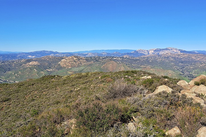
On the peak, I snapped some photos of several familiar plants, including a San Diego County sunflower. Then I scrambled up a nearby boulder and looked out with wonder on the familiar land stretching out before me. The day was clear and my eyes were far-seeing. To the west, I found the gray silhouettes of San Clemente and Catalina Islands, about 90 miles away. But strangely, my eyes were drawn north, where I was amazed to see a snowy peak lying low on the horizon like a white, bushy caterpillar. The stranger was too far west to be San Jacinto and too tall to be Santiago; only later when looking at a map did I discover that I was looking at Mt. Baldy, 110 miles away.
View from McGinty looking north at El Cajon Mountain and Mt Woodson.
After I got my fill of the view, I got down from the boulder. Nate’s words still echoed in my mind, so I decided to return to the conversation from earlier. Clearing my throat, I said, “After thinking it over, my goal isn’t to get people who read my articles to go on the same hikes as me. If I were, then my articles would focus on the trail, not my experience on the trail. Instead, I’m trying to share the importance of getting outside; to encourage people to find their own McGinty Mountain, the way you did.”
Nate sipped some water from his CamelBak with an expression that was both thoughtful and intense. Clearly, he had been waiting for this conversation to resume and I braced for a full-on assault about how I was wrong. But then Nate said, “I love these trails, and yeah, I feel selfish and want to keep them to myself, but who am I to dictate who should or should not go hiking?”
I was too dumbfounded to respond, and the resounding silence was filled by the rustle of grasses as a gentle breeze sailed by. Then Nate continued, “It’s the same mindset people have when they say, ‘Well I want affordable housing, but not in my backyard.’ Eff that, man. If you got more people on the trail and those people all learned to respect the outdoors, then maybe we’d have more sustainable-thinking hikers. And that doesn’t feel like a bad thing.” As he spoke, I gently kicked at the ground with my boot. It was red and silty with a bit of clay mixed in. Then we started talking again and I considered his words with care.
An hour later, we had moseyed back to the parking lot. Nate no longer lives in San Diego and we both knew it would be a while before we would see each other again, so we said goodbye and wished each other the best. Walking back to my car, I heard Nate holler from behind, “You know, feel free to mention my secret path. Just don’t tell people where it is.” As I spun around to look at him, sunlight washed over my face and blinded me. Even though I could barely see him against the light, I still recognized enough of my friend to smile warmly and nod.
Just as the leaves renew with the arrival of spring, so too did my friendship with Nate renew during the journey back. I suppose I had forgotten how good friends don’t just support each other, but they hold each other accountable; and in so doing, bring out the best in each other.
Here's something you might be interested in.
The Enemy on McGinty Mountain
"Who am I to dictate who should or should not go hiking?”
The Enemy on McGinty Mountain
"Who am I to dictate who should or should not go hiking?”
View from McGinty looking west at San Miguel.
- McGinty Mountain
- Located near Jamul, McGinty Mountain is a moderately strenuous hike. With a length of 4.5 miles and an elevation gain of around 1,300 feet, the hike will take most people 2 to 3 hours to complete. Dogs are allowed.
- Distance from downtown San Diego: 19 miles
- Hike length: 4.5 miles • Difficulty: Moderately strenuous • Season: November - May
“You’re the enemy now, dude,” hissed Nate.
Nate is a close friend of mine who I’ve known for about six years, and like me, he enjoys a difficult hike. The two of us were snaking our way up McGinty Mountain, which overlooked Jamul and Rancho San Diego. Nate grew up in the area, and it was one of his favorite hikes.
“I’m the enemy?” I asked teasingly while looking out at Jamul. The sky was crystal-clear with nary a cloud in sight, and the valley was lush with green from the recent rainstorms.
“You are,” Nate growled. “First you wrote about Lawson Peak, and now you’re going to write about McGinty. You’re revealing all my favorite hiking spots!” His face was completely flushed, but I couldn’t tell whether it was red with rage or ruddy from exhaustion. Nate cleared his throat: “If you keep writing about these remote hikes, we’re going to start bumping into tech bros who wear Patagonia fleece vests and blast music on the trail. Is that what you want? To turn every hiking trail into the frontside of Cowles?”
Plateau with chairs overlooking Jamul.
I smiled slyly and quipped back, “So then I shouldn’t write about your alternative route up McGinty?”
“Absolutely off limits!” Nate boomed, his voice stern. “You’d be a real S.O.B if you told people about my secret path.”
“Mmmk,” I muttered while typing his response into my phone to reference later for this article. “But just so you know, you sound like a Karen — using your own privilege to demand things be done your way.” I expected Nate to quip back, but to my surprise, he remained silent. I lifted my head to look at his face and saw it was flush with rage. I wanted my words to sting, not to insult. I sighed, irritated by my mouth’s inability to play nice.
Over the next few minutes, I endured an awkward silence. I could tell Nate was chewing over some harsh words for me, but he kept quiet. Fortunately — and no one tells you this — one of the upsides to hiking a lot is that you get used to chafing, especially when two people butt heads. Eventually, we both smoothed over our ruffled feathers and resumed chatting, though we stuck to more pleasant topics.
Flat broad ridge that winds behind mansions.
As we bantered, Nate and I climbed up the first of McGinty’s two steep sections. Here, the path slopes up from the parking lot into a series of gentle switchbacks; hikers gain about 550 feet over three-quarters of a mile. As a reward, they are met by a small plateau that overlooks Jamul. To our surprise, someone had carried up two colorful Adirondack chairs and planted them near the edge of the hill so that we could sit and take in the view. This time of year, the valley below looked like a small village: grassy meadows mixed with half-hidden homes. Surrounding the valley was a ring of hills that receded into the distance until they lapped against the base of San Miguel Mountain to the east and Otay Mountain to the south. But Nate and I never stop to rest until we reach the peak, so I snapped a photo and we carried on.
Halfway up the second steep section.
The path briefly climbed before leveling off along a broad ridge that meandered behind several picturesque mansions. As we passed the homes, we began the second steep section of the hike. Here, the ground rises sharply and gains 600 feet of elevation over three-quarters of a mile. As our breathing became more labored and the conversation withered, I lowered the brim of my hat so that I could see only six feet ahead of me. I’ve found that by looking down and focusing on my breathing, it’s easier to endure the climb. Still, I had a hard time slipping into the flow. In the back of my mind, Nate’s words were gnawing at me. I felt that he was partially right, and that by writing about local hikes, I was potentially contributing to their overcrowding.
McGinty Mountain Peak.
On the peak, I snapped some photos of several familiar plants, including a San Diego County sunflower. Then I scrambled up a nearby boulder and looked out with wonder on the familiar land stretching out before me. The day was clear and my eyes were far-seeing. To the west, I found the gray silhouettes of San Clemente and Catalina Islands, about 90 miles away. But strangely, my eyes were drawn north, where I was amazed to see a snowy peak lying low on the horizon like a white, bushy caterpillar. The stranger was too far west to be San Jacinto and too tall to be Santiago; only later when looking at a map did I discover that I was looking at Mt. Baldy, 110 miles away.
View from McGinty looking north at El Cajon Mountain and Mt Woodson.
After I got my fill of the view, I got down from the boulder. Nate’s words still echoed in my mind, so I decided to return to the conversation from earlier. Clearing my throat, I said, “After thinking it over, my goal isn’t to get people who read my articles to go on the same hikes as me. If I were, then my articles would focus on the trail, not my experience on the trail. Instead, I’m trying to share the importance of getting outside; to encourage people to find their own McGinty Mountain, the way you did.”
Nate sipped some water from his CamelBak with an expression that was both thoughtful and intense. Clearly, he had been waiting for this conversation to resume and I braced for a full-on assault about how I was wrong. But then Nate said, “I love these trails, and yeah, I feel selfish and want to keep them to myself, but who am I to dictate who should or should not go hiking?”
I was too dumbfounded to respond, and the resounding silence was filled by the rustle of grasses as a gentle breeze sailed by. Then Nate continued, “It’s the same mindset people have when they say, ‘Well I want affordable housing, but not in my backyard.’ Eff that, man. If you got more people on the trail and those people all learned to respect the outdoors, then maybe we’d have more sustainable-thinking hikers. And that doesn’t feel like a bad thing.” As he spoke, I gently kicked at the ground with my boot. It was red and silty with a bit of clay mixed in. Then we started talking again and I considered his words with care.
An hour later, we had moseyed back to the parking lot. Nate no longer lives in San Diego and we both knew it would be a while before we would see each other again, so we said goodbye and wished each other the best. Walking back to my car, I heard Nate holler from behind, “You know, feel free to mention my secret path. Just don’t tell people where it is.” As I spun around to look at him, sunlight washed over my face and blinded me. Even though I could barely see him against the light, I still recognized enough of my friend to smile warmly and nod.
Just as the leaves renew with the arrival of spring, so too did my friendship with Nate renew during the journey back. I suppose I had forgotten how good friends don’t just support each other, but they hold each other accountable; and in so doing, bring out the best in each other.
Comments