Here's something you might be interested in.
Ask a Hipster — Advice you didn't know you needed
Big Screen — Movie commentary
Blurt — Music's inside track
Booze News — San Diego spirits
Classical Music — Immortal beauty
Classifieds — Free and easy
Cover Stories — Front-page features
Drinks All Around — Bartenders' drink recipes
Excerpts — Literary and spiritual excerpts
Feast! — Food & drink reviews
Feature Stories — Local news & stories
Fishing Report — What’s getting hooked from ship and shore
From the Archives — Spotlight on the past
Golden Dreams — Talk of the town
The Gonzo Report — Making the musical scene, or at least reporting from it
Letters — Our inbox
Movies@Home — Local movie buffs share favorites
Movie Reviews — Our critics' picks and pans
Musician Interviews — Up close with local artists
Neighborhood News from Stringers — Hyperlocal news
News Ticker — News & politics
Obermeyer — San Diego politics illustrated
Outdoors — Weekly changes in flora and fauna
Overheard in San Diego — Eavesdropping illustrated
Poetry — The old and the new
Reader Travel — Travel section built by travelers
Reading — The hunt for intellectuals
Roam-O-Rama — SoCal's best hiking/biking trails
San Diego Beer — Inside San Diego suds
SD on the QT — Almost factual news
Sheep and Goats — Places of worship
Special Issues — The best of
Street Style — San Diego streets have style
Surf Diego — Real stories from those braving the waves
Theater — On stage in San Diego this week
Tin Fork — Silver spoon alternative
Under the Radar — Matt Potter's undercover work
Unforgettable — Long-ago San Diego
Unreal Estate — San Diego's priciest pads
Your Week — Daily event picks
Take an alternative scenic route to Cuyamaca Peak
Conjeos Trail Loop via Milk Ranch Road
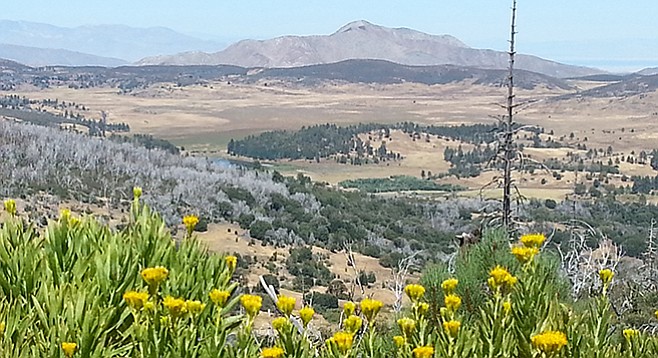
View of Cuyamaca Lake from Conejos Trail
The Conejos Trail in Cuyamaca Rancho State Park is a beautiful, less-traveled trail with a striking view of Lake Cuyamaca to the northeast, Middle Peak and North Peak to the north, and El Capitan Reservoir to the west. The trail provides the option of climbing the park’s highest and San Diego County’s second-highest peak, Cuyamaca Peak (6512 feet), from a new direction.

New growth along the Conejos trail since the 2007 Cedar Fire
The Conejos Trail looks down on lands that once belonged to the Los Conejos Band of Kumeyaay Indians who lived on Capitan Grande Indian Reservation. Conejos, which means “rabbits” in Spanish, is actually a partial translation of a Kumeyaay word meaning “rabbit house,” referring to the name of the Indian village where the Los Conejos Band lived.
Conejos is also the name of one of the most destructive fires that burned in the Cuyamaca in the 1950s. The fire actually began 4000 feet below Cuyamaca Peak on the Capitan Grande Reservation and a hot, dry wind propelled the fire toward the Cuyamacas and past Conejos Creek, eventually burning 10,000 acres of parkland.

Butterflies flutter along the Conejos trail.
Begin the hike at the trout pond near Hual Cu-Cush equestrian staging area. Look for tiny checkerspot butterflies that might be seen in this area. Follow the Milk Ranch Road past well-developed oak trees, mountain mahogany, and spicebush, to where Azalea Spring Fire Road branches off on the left and continues for 1000 feet before branching to the right onto the Conejos Trail. Mountain bikers may be encountered on the roads up to this point, but not beyond where the Conejos Trail begins. The trail is rough in spots, with steep switchbacks, narrow spots, steps, stumps, and boulders strewn across the path. You will pass a graveyard of bone-white trees from the 2007 Cedar Fire. The cleared vegetation does leave a few nice viewpoints. The trail will continue to rise in elevation until an area of new growth of pine and fir is encountered. Finally, the trail will meet the Lookout Road and a decision needs to be made whether to take the trail up the peak, which means climbing another 382 feet over half a mile, or skipping the peak and beginning the hike back down.
Lookout Road is wide and smooth, but very steep. Azalea Spring Fire Road meets up with Lookout Road on the left (north) after 1.1 miles. Follow this trail a little over a mile to meet the Milk Ranch Road and turn right (east) to return to the trailhead.

Conejos trailmap
Distance from downtown San Diego: 53 miles. Allow 60 minutes driving time (Cuyamaca Rancho State Park). Take I-8 E and exit at SR-79/Japatul Valley Rd. Drive north on SR-79 for 13.5 miles and park off road at the Trout Pond across from Milk Ranch Rd. (1.5 miles past the entrance to Paso Picacho Campground), just before SR-79 N turns right. No facilities.
Hiking length: 7.7 or 8.7-mile loop. Allow 4–5 hours.
Difficulty: Strenuous. Elevation gain/loss 1500–1850 feet, depending on optional peak climb. No facilities or water. Dogs not allowed on trails or unpaved fire roads within the park. Mountain bikes allowed on Milk Ranch, Azalea Spring, and Lookout roads only, including Cuyamaca Peak, but not on Conejos Trail.
Here's something you might be interested in.
Take an alternative scenic route to Cuyamaca Peak
Conjeos Trail Loop via Milk Ranch Road
Take an alternative scenic route to Cuyamaca Peak
Conjeos Trail Loop via Milk Ranch Road
View of Cuyamaca Lake from Conejos Trail
The Conejos Trail in Cuyamaca Rancho State Park is a beautiful, less-traveled trail with a striking view of Lake Cuyamaca to the northeast, Middle Peak and North Peak to the north, and El Capitan Reservoir to the west. The trail provides the option of climbing the park’s highest and San Diego County’s second-highest peak, Cuyamaca Peak (6512 feet), from a new direction.
New growth along the Conejos trail since the 2007 Cedar Fire
The Conejos Trail looks down on lands that once belonged to the Los Conejos Band of Kumeyaay Indians who lived on Capitan Grande Indian Reservation. Conejos, which means “rabbits” in Spanish, is actually a partial translation of a Kumeyaay word meaning “rabbit house,” referring to the name of the Indian village where the Los Conejos Band lived.
Conejos is also the name of one of the most destructive fires that burned in the Cuyamaca in the 1950s. The fire actually began 4000 feet below Cuyamaca Peak on the Capitan Grande Reservation and a hot, dry wind propelled the fire toward the Cuyamacas and past Conejos Creek, eventually burning 10,000 acres of parkland.
Butterflies flutter along the Conejos trail.
Begin the hike at the trout pond near Hual Cu-Cush equestrian staging area. Look for tiny checkerspot butterflies that might be seen in this area. Follow the Milk Ranch Road past well-developed oak trees, mountain mahogany, and spicebush, to where Azalea Spring Fire Road branches off on the left and continues for 1000 feet before branching to the right onto the Conejos Trail. Mountain bikers may be encountered on the roads up to this point, but not beyond where the Conejos Trail begins. The trail is rough in spots, with steep switchbacks, narrow spots, steps, stumps, and boulders strewn across the path. You will pass a graveyard of bone-white trees from the 2007 Cedar Fire. The cleared vegetation does leave a few nice viewpoints. The trail will continue to rise in elevation until an area of new growth of pine and fir is encountered. Finally, the trail will meet the Lookout Road and a decision needs to be made whether to take the trail up the peak, which means climbing another 382 feet over half a mile, or skipping the peak and beginning the hike back down.
Lookout Road is wide and smooth, but very steep. Azalea Spring Fire Road meets up with Lookout Road on the left (north) after 1.1 miles. Follow this trail a little over a mile to meet the Milk Ranch Road and turn right (east) to return to the trailhead.
Conejos trailmap
Distance from downtown San Diego: 53 miles. Allow 60 minutes driving time (Cuyamaca Rancho State Park). Take I-8 E and exit at SR-79/Japatul Valley Rd. Drive north on SR-79 for 13.5 miles and park off road at the Trout Pond across from Milk Ranch Rd. (1.5 miles past the entrance to Paso Picacho Campground), just before SR-79 N turns right. No facilities.
Hiking length: 7.7 or 8.7-mile loop. Allow 4–5 hours.
Difficulty: Strenuous. Elevation gain/loss 1500–1850 feet, depending on optional peak climb. No facilities or water. Dogs not allowed on trails or unpaved fire roads within the park. Mountain bikes allowed on Milk Ranch, Azalea Spring, and Lookout roads only, including Cuyamaca Peak, but not on Conejos Trail.
Comments